How To Check if Your House is in a Flood Zone in Connecticut
See How We're Different
or call us: (888) 585-5188
20 April 2026
Connecticut's geography, with over 90 miles of Long Island Sound coastline and hundreds of inland rivers and streams, places a significant number of properties at risk of flooding. Whether a home sits along the Housatonic River in New Milford or a few blocks from the shore in Fairfield, understanding flood exposure is not optional: it is a financial necessity. Residential flood insurance policies in Connecticut average about $2,200 per year, and that figure can climb sharply for homes in high-risk areas. Knowing how to check if a house is in a flood zone in Connecticut can save thousands of dollars and prevent devastating surprises after a storm. The process involves several free tools, local government resources, and federal databases that any homeowner or prospective buyer can access. This guide walks through each method, explains the zone designations, and outlines the steps to take once the results are in hand.
Understanding Flood Risk in Connecticut
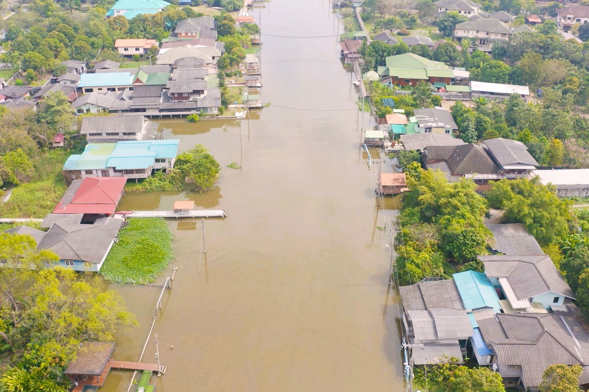
Connecticut experiences flooding from a variety of sources, and the risk is not limited to beachfront properties. The state's dense network of rivers, aging dam infrastructure, and increasing frequency of heavy rainfall events all contribute to a flood risk profile that affects communities from Greenwich to Putnam. Sea level rise projections add another layer of concern: the Connecticut Institute for Resilience and Climate Adaptation (CIRCA) recommends planning for sea levels to be 20 inches higher than the national tidal datum in Long Island Sound by 2050. That projection has direct implications for property values, insurance costs, and long-term habitability along the coast.
Coastal vs. Inland Flooding Hazards
Coastal flooding in Connecticut typically results from storm surge during nor'easters and hurricanes, combined with high tides that push saltwater into low-lying neighborhoods. Towns like Milford, Stratford, and Old Saybrook have experienced repeated tidal flooding that damages foundations, corrodes utilities, and renders roads impassable. Inland flooding, on the other hand, tends to follow prolonged rainfall or rapid snowmelt that overwhelms river channels and stormwater systems. The Connecticut River valley, the Farmington River corridor, and smaller tributaries throughout Litchfield and Windham counties have all produced significant flood events in recent decades. Both types of flooding can occur simultaneously during major storms, compounding the damage.
The Role of FEMA and Flood Insurance Rate Maps (FIRMs)
FEMA produces Flood Insurance Rate Maps, commonly known as FIRMs, which serve as the official basis for determining flood risk at the property level across the United States. These maps delineate Special Flood Hazard Areas and assign zone designations that directly affect insurance requirements and premiums. Connecticut's FIRMs have undergone periodic updates, though some communities still rely on maps that are years or even decades old. One critical reality that these maps do not fully capture is the extent of flood damage outside designated zones: nearly half of all flood damage occurs outside FEMA-designated flood zones. That statistic alone should motivate every Connecticut homeowner to verify their status regardless of assumptions.
Primary Methods to Verify Your Flood Zone Status
Several reliable tools exist for checking whether a Connecticut property falls within a designated flood zone. Each method offers a different level of detail, and using more than one provides the most complete picture.
Using the FEMA Flood Map Service Center
The FEMA Flood Map Service Center (MSC) at msc.fema.gov is the primary federal resource for flood zone lookups. Homeowners can enter a street address and instantly view the corresponding FIRM panel for that location. The map will display the flood zone designation, the base flood elevation where applicable, and the effective date of the map. One limitation is that the interface can be difficult to interpret for users unfamiliar with GIS mapping. The MSC also provides access to Letters of Map Change, which document any official revisions to a property's flood zone classification since the last full map update.
Accessing the Connecticut DEEP GIS Map Viewers
The Connecticut Department of Energy and Environmental Protection (DEEP) maintains GIS-based map viewers that overlay FEMA flood data with state-specific environmental layers. These tools allow users to view flood zones alongside wetlands, watercourses, and dam inundation areas, providing a more comprehensive risk assessment than the federal maps alone. The CT ECO Map Viewer is particularly useful because it integrates aerial imagery with flood hazard boundaries, making it easier to identify a property's exact position relative to a floodplain. Accessing these viewers requires no account or fee, and they function in any standard web browser.
Reviewing Municipal Property Records and Tax Maps
Local town halls and assessor offices in Connecticut often maintain flood zone information as part of their property records. A phone call or visit to the municipal building can yield the flood zone designation listed on the property card, which is the same data used for tax assessment purposes. Some towns, such as Norwalk and New Haven, have made this information available through online GIS portals on their municipal websites. Tax maps can also reveal whether a property sits within a mapped floodway, which carries stricter building and development regulations than the broader floodplain.
Decoding Flood Zone Designations for CT Homeowners
Understanding what each zone label means is just as important as knowing which zone applies to a given property. The designations carry direct financial and regulatory consequences.
High-Risk Zones: Special Flood Hazard Areas (SFHA)
Special Flood Hazard Areas are zones where FEMA has determined there is at least a one percent chance of flooding in any given year, commonly referred to as the 100-year floodplain. These zones carry designations such as A, AE, AO, AH, V, and VE. The "V" zones are specific to coastal areas where wave action compounds the flood risk, and they carry the highest insurance premiums and strictest building codes. Any property with a federally backed mortgage in an SFHA is required by law to carry flood insurance. The table below summarizes the most common high-risk designations found on Connecticut FIRMs.
| Zone | Description | Common CT Locations |
|---|---|---|
| A | 100-year floodplain, no base flood elevation determined | Rural river corridors |
| AE | 100-year floodplain with base flood elevation | Most mapped riverine and coastal areas |
| VE | Coastal high-hazard area with wave action | Shoreline towns along Long Island Sound |
| AO | Sheet flow flooding, 1-3 feet deep | Low-gradient areas near streams |
Moderate to Low-Risk Zones: B, C, and X
Properties outside the SFHA receive designations of B, C, or X, depending on the map vintage. On newer FIRMs, Zone X (shaded) indicates a moderate risk, roughly corresponding to the 500-year floodplain, while Zone X (unshaded) indicates minimal risk. Older maps may still use Zone B for moderate risk and Zone C for minimal risk. Flood insurance is not federally required in these zones, but it remains available and is often far less expensive. Given that a substantial portion of flood claims originate from properties in these lower-risk designations, dismissing the need for coverage based solely on a Zone X classification is a common and costly mistake.
Essential Local Resources for Connecticut Residents
Beyond federal and state mapping tools, Connecticut offers several local resources that can help homeowners understand and manage their flood risk.
Consulting with Your Local Floodplain Manager
Every community participating in the National Flood Insurance Program is required to designate a local floodplain manager, and all 169 Connecticut municipalities participate. This official can provide site-specific information about flood zone boundaries, local ordinances governing construction in floodplains, and the history of flooding in a given area. Floodplain managers are typically housed within the town's planning, zoning, or building department. They can also explain whether the community has adopted regulations that exceed FEMA minimums, which may affect building permits and renovation projects. A direct conversation with this official is one of the most underused yet valuable steps a homeowner can take.
The Impact of the National Flood Insurance Program (NFIP) in CT
The NFIP provides the backbone of flood insurance availability in Connecticut, and the program's Community Rating System (CRS) offers a tangible financial incentive for municipalities that go beyond baseline requirements. Communities that implement enhanced floodplain management practices can earn CRS credits that translate into insurance premium discounts of up to 45 percent for policyholders within their jurisdiction. The average cost of flood insurance in Connecticut is $1,426 per year, though actual premiums vary significantly based on zone designation, building elevation, and coverage limits. Checking whether a municipality participates in the CRS, and at what class level, can reveal potential savings that many homeowners overlook.
Next Steps After Determining Your Flood Risk
Once a property's flood zone status is confirmed, several follow-up actions can either reduce insurance costs or correct an inaccurate classification.
Obtaining an Elevation Certificate
An Elevation Certificate is a standardized FEMA form completed by a licensed surveyor that documents the elevation of a building's lowest floor relative to the base flood elevation. This document is critical for accurate insurance rating, and it can result in significantly lower premiums if the building sits above the base flood elevation. The cost of obtaining an Elevation Certificate in Connecticut typically ranges from $300 to $600, depending on the surveyor and property complexity. For homes in the SFHA, this certificate is often required before a flood insurance policy can be issued. Even for properties outside high-risk zones, having one on file provides valuable documentation.
Applying for a Letter of Map Amendment (LOMA)
A Letter of Map Amendment is a formal determination by FEMA that removes a property or structure from the SFHA based on elevation data showing it sits above the base flood elevation. Homeowners who believe their property has been incorrectly mapped into a high-risk zone can submit a LOMA application to FEMA at no cost, provided they include a completed Elevation Certificate and supporting documentation. Approval of a LOMA can eliminate the mandatory flood insurance requirement for properties with federal mortgages, saving homeowners hundreds or thousands of dollars annually. The review process typically takes 60 to 90 days, and the determination remains valid until the next map revision.
Frequently Asked Questions
Is flood insurance required if my Connecticut home is not in a high-risk zone? Federal law does not require flood insurance for properties outside the SFHA, but lenders may still require it based on their own risk assessments. Purchasing a policy voluntarily is often wise, since a significant share of flood claims come from lower-risk zones.
How often does FEMA update flood maps in Connecticut? FEMA updates maps on a community-by-community basis, and there is no fixed schedule. Some Connecticut towns have maps that are relatively current, while others rely on data that is over a decade old.
Can I get flood insurance if my community does not participate in the NFIP? All 169 Connecticut municipalities currently participate in the NFIP, so this is not an issue for CT residents. Private flood insurance is also available as an alternative or supplement.
Does my homeowners insurance cover flood damage? Standard homeowners insurance policies in Connecticut do not cover flood damage. A separate flood insurance policy, through the NFIP or a private carrier, is required for flood protection.
How much does flood insurance cost in Connecticut? Costs vary widely. Residential policies average around $2,200 per year, while commercial policies average approximately $4,500 per year, though individual premiums depend on zone, elevation, and coverage amount.
Making the Right Flood Risk Decision
Determining whether a Connecticut property sits in a flood zone is a straightforward process that requires nothing more than an internet connection and a few minutes of research. The FEMA Flood Map Service Center, Connecticut DEEP map viewers, and local municipal records each provide a different angle on the same question. Homeowners who take the additional steps of obtaining an Elevation Certificate or pursuing a LOMA where warranted can protect themselves from both unnecessary insurance costs and unexpected flood losses. Flood risk in Connecticut is real, evolving, and not always reflected on older maps, so proactive verification is the most reliable defense against financial exposure.
Recent posts